Jasa Survey Topografi Pemetaan - Surveyor
Product Image


Jasa Survey Topografi Pemetaan - Surveyor
Category
Last Update
06 / 01 / 2022
MinimumPurchase
1 Set
Visited
29 Times
Price
CALL
Share
Add To Cart
Attention!
This company is registered as a Free Member. Avoid making payments before meeting the seller or seeing the goods in person. COD (Cash On Delivery) or meeting directly with the seller is a safe transaction method that we recommend.
Specification of Jasa Survey Topografi Pemetaan - Surveyor
Browse through the extensive list of Surveyor. Find the best offer from thousand of supplier in Indonetwork.
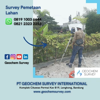
Topographical surveys will help you to make plans or maps of an area that show: the main physical features on the ground, such as rivers, lakes, reservoirs, roads, forests or large rocks; or the various features of the fish-farm, such as ponds, dams, dikes, drainage ditches or sources of water; the difference in height between land forms, such as valleys, plains, hills or slopes; or the difference in height between the features of the fish-farm. These differences are called the vertical relief.
PT. Geochem Survey International
PT. Geochem Survey International. Konsultan Geologi, Geofisika, dan Geoteknik.
Tenaga ahli Geochem Survey pengalaman dalam Konsultan Jasa Survey Geofisika, Geolistrik, Soil Resistivity Testing, Soil Thermal Resistivity, Georadar / GPR (Ground Penetrating Radar), Seismik refraksi, refleksi, MASW (Multi-channel Analysis of Surface Waves), Downhole Borehole Seismic, Gravitasi Gaya berat (Gravity), Geomagnet (Magnetik), Pemetaan Geologi (Geological mapping), Hidrogeologi, Hidrologi, Geodesi, Surveyor Topografi, Bathymetry, Drone UAV, LiDAR (Pemetaan Kontur dan Foto Udara), GIS / SIG (Sistem Informasi Geografis), Geoteknik, Soil Test, Investigation, Sondir, CPT, CPTu, CBR, Boring SPT, Coring, MetOcean (Meteorologi dan Oseanografi), Hidrografi, Batimetri, Uji NDT (Non Destructive Test), Tambang (RKAB, Eksplorasi Emas, Mineral, Batubara, Sumur bor air tanah, Pembuatan Peta WIUP, IUP, OP, Feasibility Study – Studi Kelayakan), Izin Lingkungan (AMDAL, UKL UPL, SPPL). Kami juga menyediakan jasa Training / Pelatihan, Perbaikan / Service, Jual Beli, dan Rental Sewa Alat.
Tenaga ahli Geochem Survey pengalaman dalam Konsultan Jasa Survey Geofisika, Geolistrik, Soil Resistivity Testing, Soil Thermal Resistivity, Georadar / GPR (Ground Penetrating Radar), Seismik refraksi, refleksi, MASW (Multi-channel Analysis of Surface Waves), Downhole Borehole Seismic, Gravitasi Gaya berat (Gravity), Geomagnet (Magnetik), Pemetaan Geologi (Geological mapping), Hidrogeologi, Hidrologi, Geodesi, Surveyor Topografi, Bathymetry, Drone UAV, LiDAR (Pemetaan Kontur dan Foto Udara), GIS / SIG (Sistem Informasi Geografis), Geoteknik, Soil Test, Investigation, Sondir, CPT, CPTu, CBR, Boring SPT, Coring, MetOcean (Meteorologi dan Oseanografi), Hidrografi, Batimetri, Uji NDT (Non Destructive Test), Tambang (RKAB, Eksplorasi Emas, Mineral, Batubara, Sumur bor air tanah, Pembuatan Peta WIUP, IUP, OP, Feasibility Study – Studi Kelayakan), Izin Lingkungan (AMDAL, UKL UPL, SPPL). Kami juga menyediakan jasa Training / Pelatihan, Perbaikan / Service, Jual Beli, dan Rental Sewa Alat.
PT. Geochem Survey International
Free
Komplek Cikawao Permai Kav B19, Lengkong, Bandung - Kota Bandung, Jawa Barat, Indonesia -40261
Last Login 15 / 01 / 2024